Waterford, NY and the first 6 locks of the Erie Canal (#2-7)
After a restful night docked at the wall at Waterford Harbor Visitors Center, we are prepped for our entrance into the Erie Canal. Steve has been looking forward to navigating the Erie Canal since the beginning of this adventure. We could spend the entire summer experiencing the towns, the locks, the museums, and the canal village at Rome, but we have territory to cover and much to see before the summer is over.
Today, we will transit Locks #2-7.
So, where is the Erie Canal?
Start in the east by Albany and Waterford is just above.
Waterford, NY is the eastern gateway to the NY State Canal System. The area was settled in 1622 by Dutch fur traders, and Mahican families lived on nearby Pebbles Island. By the late 1700's, sea captains were bringing their sloops up the Hudson River to trade. The Appalachian Mountains stood in the way of westward expansion, except for the break in the valley where the Mohawk River flowed by Waterford. The idea of a canal was conceived and the canal was constructed. Canal laborers were paid $.80-$1 a day. By 1825, the area was bustling with canal boats traveling west along the Erie Canal to and from the Great Lakes and the interior of America. As we walked through the historic district of Waterford, we saw many homes with architecture from the 1800's when the area was booming.
Before entering the Erie Canal, Steve purchased our $100 seasonal locking pass from the lockmaster at lock #2. This pass entitles us to tie up without charge at most town docks with some places providing free electrical and water.

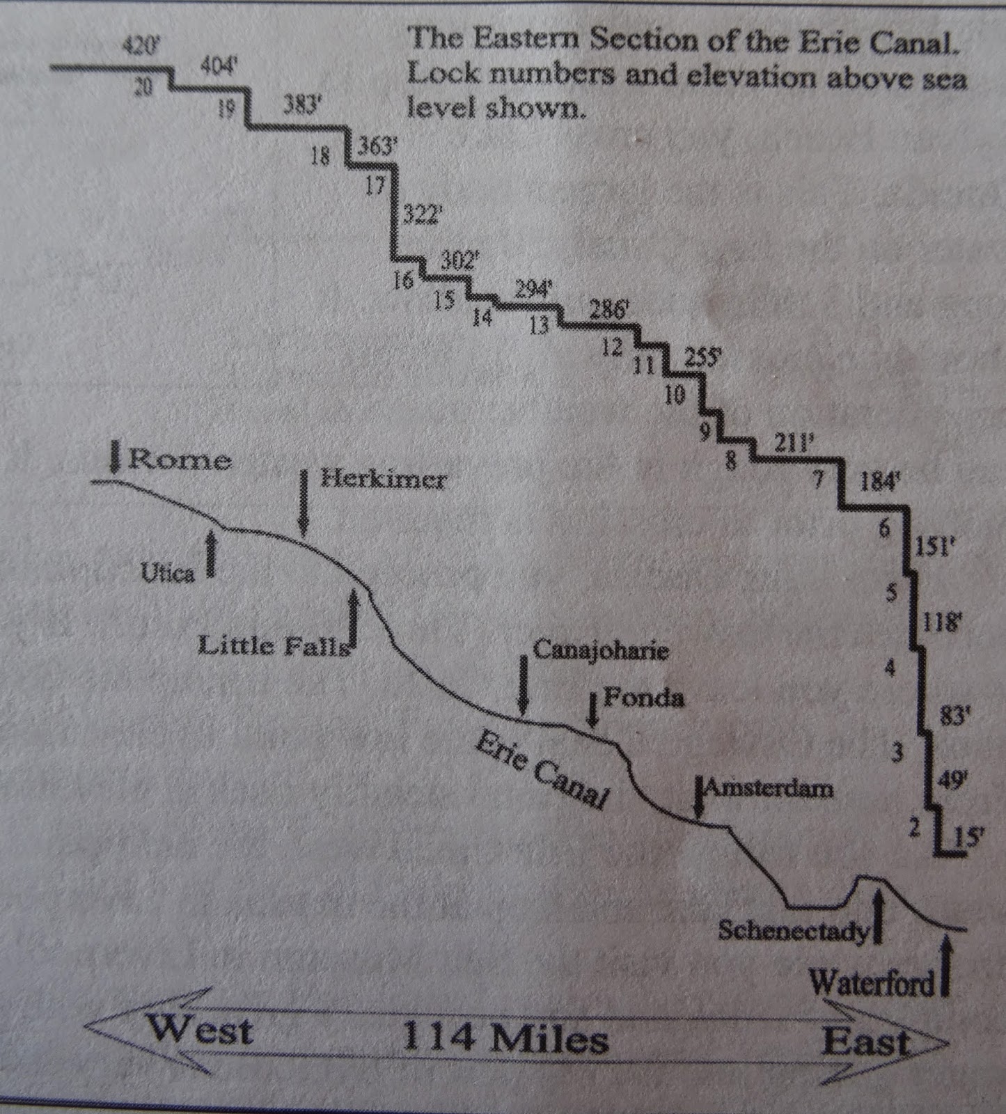
The Erie Canal, completed in 1825, is part of the NY State Canal System. The canals were the answer to getting goods from the East Coast to the Great Lakes in a shorter period of time. Every major city in NY is found along the trade route established by the Erie Canal. The Erie Canal was over 340 miles long and connected Troy, NY on the Hudson River with Buffalo, NY on Lake Erie. As the railroads developed, the use of the canals decreased, the canals fell into disrepair, and some small canals were abandoned. Today, the Erie Canal rises 566 ft. from the Hudson River to Lake Erie through 57 locks beginning at Troy, NY to an elevation at 420 ft. above sea level at Rome, NY. Originally built for commercial traffic, since 1990, the canal has been used primarily for recreational traffic. The canal system provides 400 miles of cruising for boaters whether leaving or going to the Great Lakes.
The locks are open from 7 am-10 pm. The speed limit is 5-10 mph.
On the Erie Canal you are living life in the past lane.
It's an area rich with history!
The Eastern Section of the Erie Canal.
The map/chart above shows the locks and elevation of the Eastern Section of the Erie Canal.
We will be transversing the entire 341 miles of the Erie Canal from Troy, NY to Buffalo, NY on Lake Erie. The canal is known for quaint and picturesque villages with warm welcoming people.
The chart below shows the changes the Erie Canal has experienced.
For boaters planning to motor the Erie Canal, a Skipper Bob Publication: Cruising the New York Canal System is a "must have". Updated annually, it provides all the info for transiting and enjoying the canal. Once you understand the workings of the locks and what to expect, your cruising will be much more enjoyable.
Vessels normally enter locks in groups. The first boat takes a spot on either wall and the boats (following alternate sides) tie up close to the vessel ahead.
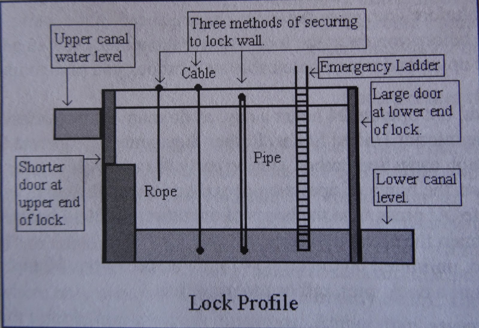
Below is a lock profile which shows the three methods of securing to the lock wall. Navigating the numerous locks on the river system has prepared us for the Erie Locks. You will definitely want an old pair of gloves as the ropes are wet, dirty, and slimy. You are on your own to handle the tie up; lock crews are busy with other jobs.
These lock information markers
are located at each of the locks.
By 8 am, we were prepped and ready for to enter Lock #2 only 300 ft. away.
We had received a report that after 9 am today, that lock #2 would be closed due to maintenance and who knows when it would open again for boat traffic. Boats were eagerly lining up for the lock opening, and about 8:15 am, the locks swung open and the caravan of boats jockeyed for positions in the lock.
There's not much to see when your boat is at the bottom of the lock.
See the picture below. Just think of all the water being held back by that lock wall, and if for some reason, something went wrong...Mary has a vivid imagination!
But before long, you are at the top, ready to drop the slimy line, and move on. Even the captain has to help work the lines in the locks.
We are in a caravan of six boats.
The picture above shows guard/flood gates which are dropped down thus forcing the water to back up and go over the natural falls. These gates are used to alleviate damage to the locks (#2-5) when there is a need for water control during heavy rains, storms, or hurricanes.
These six locks are fairly close together and gave the crew lots of practice with locking through!
The Erie Canal is a form
of entertainment whether
you are traveling in a
boat or watching the boats
go by. We have had many
curious onlookers
during locking, while motoring,
and while docked. What a
great little spot to watch
the world go by. A little
bread, cheese, and wine...
It's a small world! We were having lunch while waiting for our plane at the Albany Airport, and who should walk into the restaurant but fellow loopers, Anita and Don Gulseth. They were flying home for a graduation.


No comments:
Post a Comment